FORMOsa SATellite mission-7/Constellation Observing System for Meteorology, Ionosphere, and Climate mission-2 (FORMOSAT-7/COSMIC-2) is a Taiwan-U.S. collaborative mission between the National Space Organization of Taiwan and the National Oceanic and Atmospheric Administration (NOAA) of the United States. FORMOSAT-7/COSMIC-2 successfully observed atmospheric and ionospheric profile yesterday (July 16) and completed the first inversion today. However, it is still only at testing stage. It is expected that after the scientific research team completes the validation of the data in the 7th month after launch, the ionospheric and atmospheric data will be publicly released to the users' community. Interested parties can visit and access the data from the National Space Organization's (NSPO) website with the following link: http://www.nspo.narl.org.tw/tw2015/info/fs-data.html.
FORMOSAT-7/COSMIC-2 satellites were launched by the Falcon Heavy of US Space Exploration Technologies Corp. (SpaceX) at 14:30 p.m. on June 25th, Taiwan time (2:30 a.m. on June 25th, US Eastern Time), at the Kennedy Space Center (KSC) in Florida, USA. At 8:48 pm, FORMOSAT-7/COSMIC-2 satellites entered the communication range of the Taiwan Ground Stations which is the third revolution, and successfully communicated with the ground stations located in Zhongli and Tainan.
NSPO performed various subsystem inspections on FORMOSAT-7/COSMIC-2 satellites. All functional tests were checked out and turned out normal as-of-today. After successfully observing atmospheric and ionospheric profile yesterday, NSPO and US team will continue to perform the payload commissioning and check-out of the Tri-GNSS Radio occultation System (TGRS), radio frequency beacon (RFB) and ion velocity meter (IVM) instruments. The team will adjust the instrument parameters based on-orbit environment and observation to optimize the performance.
After that, NSPO, Central Weather Bureau (CWB), National Central University (NCU), and National Cheng-Kung University (NCKU) will collaborate with international atmospheric and ionospheric Research Team to calibrate and validate the FORMOSAT-7/COSMIC-2 system and perform weather forecast impact assessment. It is expected that the FORMOSAT-7/COSMIC-2 measurement data will be available to the global meteorological community in the 7th month after launch.
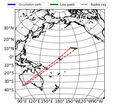 Schematic diagram of the occultation path, the green color (Leo path) is the projection of the FORMOSAT-7/COSMIC-2 orbit trajectory on the Earth, the red dotted line is the surface projection of the signal trajectory from the GPS satellite to the low-orbiting satellite, and the blue color is the event position where the occultation occurs at 7 degrees north latitude which is near the international date line (IDL).
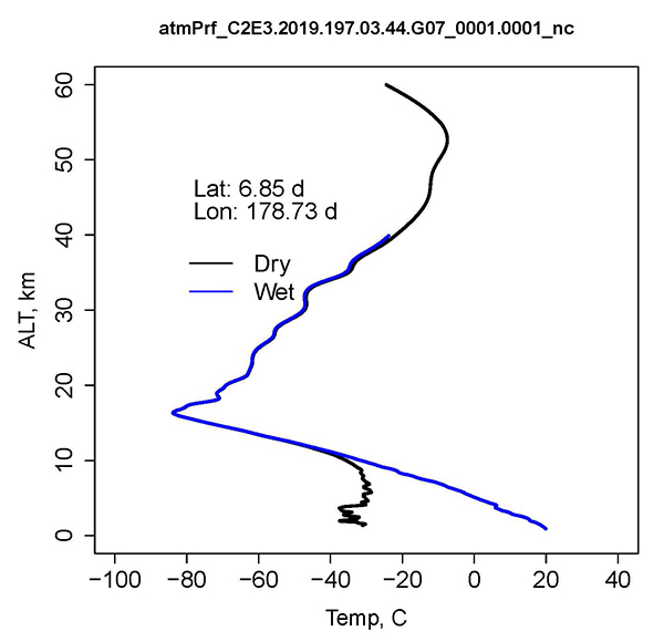 The first dry air temperature (water vapor not considered, Dry) and wet air temperature (Wet) profiles observed by FORMOSAT-7/COSMIC-2 satellite.
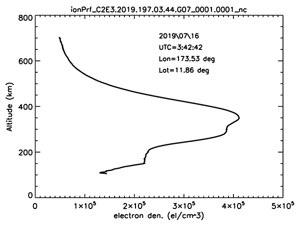 The first ionospheric electron density profile observed by FORMOSAT-7/COSMIC-2 satellite.