The research team including researchers from the Global Water Quality Research Center (GWQRC) of the Graduate Institute of Environmental Sustainability at National Cheng Kung University (NCKU), and the Instrument Technology Research Center (ITRC) at National Applied Research Laboratories (NARLabs) was invited by the Australian Water Quality Centre (AWQC) to cooperate in a three-year “advanced environmental observation project.”
Hyperspectral imaging is widely used for remote sensing. When the imaging system is carried by an airplane, it can make a quick scan from a distance to detect the light spectrum on the ground or water surface. Researchers can then analyze the environmental characteristics by applying spectrum computation and image processing to the results. In agriculture, the technology can be used to assess crop health and predict crop yield. It can also be used to detect the level of water eutrophication in water quality monitoring.
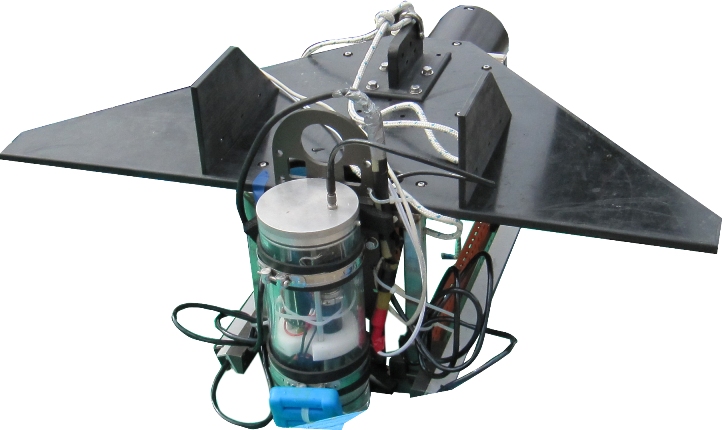
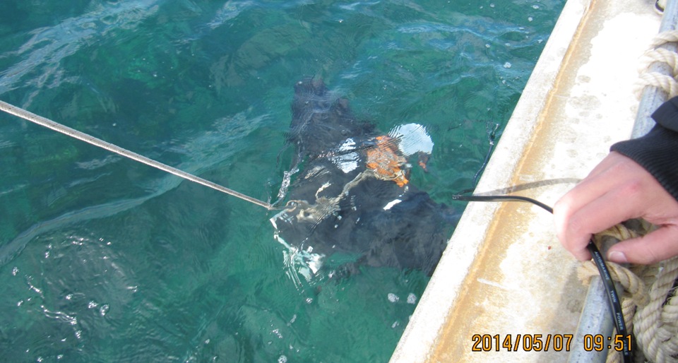
In recent years, NCKU has collaborated with Instrument Technology Research Center (ITRC) and Taiwan Ocean Research Institute (TORI) of NARLabs on the development of “underwater hyperspectral imaging technology.” The imaging system is placed in the ocean and towed by cables attached to a research vessel for remote scanning of the water quality and subaqueous ecological environment. This pioneering technique in the field of remote sensing and ocean research has received encouragement and acclaim at international conferences.
According to the Australian Department of the Environment, nearly one-third of seagrass in the South Australian maritime boundary has died off since 1950. The die-off within 2 km of the shore was attributed to heavy rain wash and water pollution, while seagrass located 4 km and beyond was not severely affected. The loss of seagrass beds is a serious concern to the Australian government because it spurs desertification in the maritime boundary and results in a barren seafloor. Not only does this threaten the survival of animals and plants in the area, it also impacts soil and water conservation.
The goal of this collaboration is to evaluate and analyze the environmental influence on seagrass distribution along the South Australian coast. The team from Taiwan was mainly responsible for providing hyperspectral imaging technology for underwater scanning and spectrum analysis. They also created the data analysis model for examining the relationship between seagrass health and water quality, as well as its impact on the environment. In the future, Taiwanese researchers will be able to use this research model for their work on environmental sustainability in Taiwan.
The GWQRC of the Sustainable Environment Research Laboratories NCKU is an international research center co-established by the AWQC, China Steel Corporation, and NCKU. In recent years, it has focused on both local and global issues related to water quality monitoring, climate change, water treatment, and water recycling. The above international project was supported by the Premier's Research and Industry Fund and executed via the collaboration of Taiwanese and Australian scientists. The Taiwanese members of the team included Dr. Long-Jeng Lee from ITRC, Dr. Tsair-Fuh Lin, director of the NCKU GWQRC, as well as Dr. Chih-Hua Chang and PhD student Charnsmorn Hwang from NCKU.
Global environmental change threatens human survival and development. Accessing information on the earth’s natural resources and local environmental change must rely on remote sensing technologies, which are critically important to crisis prevention, ecological conservation, environmental protection, local security, resource planning, and earth science research.
Under current trends in global technological advances, developed countries have invested enormous amounts of manpower and resources in the development of remote sensing in order to obtain information on the ecosystem, such as water quality, vegetation ratio, and ecological change. Relative to other developed countries, the demand for crisis prevention and environmental protection is especially urgent in Taiwan, due to its small geographic area and dense population.
As remote sensing technologies are extremely important in the prediction, prevention, and assessment of environmental change, as well as in related rescue and recovery work, these issues remain the primary emphasis in Taiwan's environmental sustainability R&D and constitute a strategic priority of technological development for the government.